Tartaria – the forgotten empire
It cannot be said often enough. Without history, we do not know who we are, where we are going, and what we are capable of. History is human strength.
Unfortunately, that is also the reason for our great weakness. Our history has been stolen from us. It has been hidden, forged and destroyed. In the best case, it is like an old machine that has ended up in a crowded barn where it has not been opened in a lifetime. The machine is littered with rags and dust, the pigeons have dropped dirt on it, and the metal is rusty. But once the thing is raised, it turns out that all the parts are intact. They just need to dip into a bucket of vinegar for a few weeks and lubricate in machine oil. It needs to be painted and tightened, V-belts need to be replaced, and new tires need to be put on. The first time it starts, black smoke comes up, but quite slowly it runs hot and turns out to be made of a quality that can no longer be bought. It is advanced for its time, but it is also much simpler, which is its great strength. Quality was the standard back then, and built-in obsolescence was not invented.
OK, the picture can’t be stretched any longer. One could also imagine something quite extraordinary. The picture starts in the same way, but the machine that appears in the barn is a model that has not been invented yet! Or rather, it was so, because it says so, but no one was aware of it. And the barn has not been opened for hundreds of years, so everyone has forgotten all about the contents.
The oblivion did not come by itself. It happened because someone wanted it. Oblivion became a weapon in the hands of the enemies of humanity, which we for the purpose may call the parasites. The term is not my invention but is borrowed from a recently emerged movement that can almost be called a school of historical revisionism. This school digs out the story of a great empire that existed… in the distant past? No until quite recently, which is the most surprising. But it has been erased in the history books. The name of the land that covered most of the Earth’s land masses was: Tartaria.

This concept of Tartaria was wiped out both physically and mentally. The annihilation took place to pave the way for the world that exists today, where the global parasite culture has its boot-trampling triumph, where people are murdered, deceived and plundered, and where we are governed by supranational super-national organizations, forums, syndicates, lodges, think tanks, etc. from distant and inaccessible positions. In other words, the global fascist hell of smearing and merging, so that there are no longer societies but only clashes behind fences. Even the national fences that could provide some protection against overrun are now being torn down. The destruction of human culture is an ongoing project.
The school that uses the terminology parasites and Tartaria mostly originates from the Russian mathematician and historian Fomenko. But his work builds on something that already existed, and he is not alone in the project. The Bulgarian historian Silvie Ivanowa has collected a large number of examples, which she disseminates on her site NewEarth. So there is an unbroken tradition, but it is so fragile that you have to look for it. An image other than the machine in the barn is a large painting. A corner of the image is cracked and you can see something else below. Upon full restoration, it turns out that there is a completely different image below. The motif, the landscape is so far the same, the buildings are in a way the same, but the figures are different and the meaning of the picture, the interpretation of the narrative is different.

In addition to being a mathematician and historian, Fomenko is also an excellent visual artist
In all countries of the world, there are buildings in what we usually call classical style. We call this style Greek or Roman, and later we call it neoclassical. They are found on all continents, and it is not because the Romans have been there, even though they reached far and wide. It is only in Roman culture that all their possessions, all their inventions, all their techniques, their language and their riches were stolen from others. Possibly their only original contribution to civilization is their special ways of equipping and setting up an army – intended to destroy civilization! The Fomenko School questions whether there was a Roman Empire at all and claims that it was all part of this worldwide great empire called Tartaria, whose infrastructure was immeasurable.
When we talk about genocide, we usually mean the annihilation of human life. We should spread the concept to include infrastructure, lifestyle, tradition and history. It is very significant that the warfare we have seen in the Middle East always involves the destruction of historical remnants of an ancient culture. It happened in Iraq, it happened in Libya, it happened in Syria (Aleppo, Palmyra), it happened in Afghanistan (Bamiyan). The Conquistadors of South America burned the books written by the Mayans and Incas describing the oldest history of mankind, and we have only fragments of Popul Vuh left. The French during Napoleon’s invasion of Egypt ravaged cartouches in the Egyptian temples because they told where Christianity got its cosmology from.
Who ordered all this systematic destruction, and what goes on in their twisted heads and minds?

The Empire’s mercenary army of terrorists and vandals has destroyed one of the most significant historical sites in the entire Middle East, Palmyra in Syria
Vandalism always goes after the remains of something old, and the invasion wars seem to be a part of what Joseph P. Farrell calls archaeological warfare. They go after the cultural treasures, and only to the extent that they constitute a value to the destroyers, do they bother to grab them – for example, the National Museum in Baghdad. The rest must be destroyed so that the people will forget who and what they are descendants of. Then their agriculture, their food culture is destroyed, their functioning economic systems are smashed with a dysfunctional debt system, their markets are filled with worthless junk, their morals are polluted with ‘liberation’, porn and Hollywood obscenities, their songs are replaced with stupid music and auto-tuner bots in smart clothes, their governments are replaced with bribed tail waggers.
Is there not a pattern to be seen here, and have we not forgotten to see it as such by accepting the general assertion that this is just evolution, unstoppable progress, just something that happened by itself? That’s what they’ll tell us. Are they telling the truth?

Never forget Dresden! And never forget, that they did the same
to all German cities with more than 25.000 inhabitants!
It was not just something that took place in the peripheral world, for Europe was bombed to pieces in two world wars. All cities in Germany with over 25,000 inhabitants were fire-bombed and destroyed. Dresden was completely leveled, because here was a wealth of the type of magnificent and impressive buildings in what we might then call Tartaria style, a classic building style of the same worldwide distribution as Tartaria itself. Mainstream history tends to call the building style colonial-style. It presupposes that it was the colonial power that arrived with it, and that the under-developed inhabitants either lived in earthen caves and thatched huts and were unable to produce grandiose architecture or built in a completely different style. When Europeans came to China, they saw a different style that matched theirs, but the Fomenko school points out that the so-called classical building style existed before the imperialists arrived. A better example is Japan, specifically old Tokyo.

The picture shows the old town of Tokyo. If we saw the picture and guessed, we would say somewhere in Europe. The special thing about Japan is that it was a closed country for foreigners for a long time. Only at the beginning of the last century did Europeans and Americans succeed in forcing access, and it was not with the good will of the Japanese, for they did not trust the parasitic imperialists, their gunboats, their falsehood and greed. There is therefore no evidence that the building style did not already exist.
What are we talking about to an extent? Huge land masses. Think Eurasia today. Think Halford MacKinder’s Heartland – interesting that as a representative of the British Empire, he considers the continuum, which is largely similar to Tartaria, as the very goal of the power grab project. He who wants to rule the whole world must rule The Heartland, as he says in his tenet of imperialism, the premise, the dogma. The World Island is Asia + Europe + Asia Minor + America – MacKinder’s British Empire considered America their rightful extension. They constituted The Rimland, the land on the edge, which we may also call the Sea Empire, for all lands were largely accessible to dominance and plunder from the water side. The important resources, on the other hand, were in The Heartland, the Land Empire, which was a harder nut to crack. It also allows us to identify the parasites’ headquarters in his time, which is the classical imperialism of the mid-19th century, in which England is a leader. England created industrialism, which drew its resources from imperialist-parasitic plunder of its colonies in The Rimland. The formation of India as British was part of the eating into Tartaria that led to its disappearance from the map – and from the written world history.

One of the many historical maps shows a great empire bearing the name Tartaria. It stretches from Japan to France, from northern Siberia to Indonesia. The Tartaria culture was a non-aggressive and non-oppressive culture – diametrically opposed to the parasitic culture that attacked and destroyed it and by systematic, persistent and fierce falsification of history sent it into historical oblivion.
The Russian agrarian society in 1917 was the remnants of Tartaria. The parasites had meanwhile divided their headquarters between the City of London and Wall Street, and from both sides issued an order that Russia should be destroyed by a communist revolution. Some say the headquarters never left The City, and that certainly makes sense. A new mega-wave of vandalism and genocide in all meanings of the concept was launched in the revolution project. The effects of this destruction were only addressed after the fall of the wall, and the healing project, which was quite deliberately launched in Russia, is now being violently attacked by the parasites’ neo-Cold War campaign. Parasites can ONLY live in a polluted and toxic environment, and detox is their worst nightmare.
A declassified CIA document from June 1, 1957 with the title National Cultural Development under Communism describes what the Bolsheviks did to obliterate the history of Tartaria. There is no reason to doubt the authenticity of the document and the position that emerges. The CIA at the time was so close to its origins, the post-Nazi intelligence people (OSS), and the main enemy of the Nazis was, as you know, Stalin’s Soviet and Bolshevism.

Here we should also remember – again without glorifying Nazi Germany – that Germany’s real enemy was the Navy, which had instituted an illegitimate coup regime in Russia to rule on its behalf. That is, the real story of the Russian Revolution, not the falsified, self-glorifying story of the glorious revolutionaries who fought for the people and the working class – as they had invented for the occasion. The people were brutally massacred, and 147 million died between 1917-1990. So, strangely backwards, Hitler fought the worst enemy of the Russian people, Communism and the Imperialism that had created it. You may like this fact or not, but it is indisputable.
This would be entirely consistent with the racial ideological side of Nazism that deals with Aryan origins, for the people of Tartaria were just described as tall, blue-eyed, fair-skinned types, that is, in the same way as the Nazi ideal.

The standard objection is – because one cannot deny the many historical maps from the archives – that it was was a designation for a territory, a land area, as when we say Asia. But Tartaria had its own flag, the common one with an owl and the imperial one with a griffin. Emperor = Czar, Shar, Ceasar. It had its own language, its own people, and its own royal genealogy, that is, all attributes of an organized, formally great kingdom. The following family tree over the Tartar royal lines (king – khan) draws threads back to the highly mythologized figure known as Genghis Khan – here from pages 231-32 in Genealogie des Anciens Empereurs Tartares, Descenendus Ghenghiscan – a huge French Historical Atlas from 1732:

There is something strange about the story of Genghis Khan and his world tour, the Mongolian wave. Here they are called Tartars, that is, the people of Tartaria. In contemporary illustrations, neither he, Tamerlan (look in the tree after Timur) nor Bata Khan are depicted with Mongolian features:

Have historians cheated with the tale of the Mongolian nomad becoming a world conqueror? The pictures do not show skewed eyed Mongols with high cheek bones – no offense – but rather Turks. Not Turks as modern Turks but something similar to the idea of pan-Turkism, that is, precisely about a people who populated all of Asia.
The French historian Antoine Galante explains in his work Bibliotheque Orientale, ou Dictionnaire Universelle from 1695 origin to the term tartar or tatar: Descendants of d’Ilingeh Khan – Genghis Khan, the fifth king of Turkestan – not a simple nomadic shepherd-warrior – and of Japhet’s lineage. He does not elaborate on the latter, but it is a rather remarkable biblical statement. So Tartaria is populated by descendants of one of Noah’s sons! Japhet had a twin named Mogol or Mogul, which is both an ethnic designation and a title. We know it from the later Mogul dynasty in India. It also describes how the two brothers each formed their own kingdom, one in the east and one in the west, and that they were later united.
Am I making an interpretation leap here? I’m pretty much sure I do not, for a story about Noah and three sons in a wooden container ship full of animals, wife and three sons should probably not be read literally, as the Bible-belters do. The landing site Ararat in what was then Armenia, now across the border into Turkey, can easily be a precise historical fact. The vessel that sailed out of the flood has landed in a highland and the survivors have settled on a mountain until the waters withdraw. But we have to read allegorically, so when it says a name, it rather means a lineage or a whole group of survivors.
The origins of these dynasties as mentioned by Galante are also interesting, i.e. Turkestan, the present Xinqian province in China, which is related to the story of Shambala. Shambala or Cambalu is the overall form of Tartaria, which is the shape of a flatfish, a flounder. So two hints about an ancient origin. Again, these tales are dismissed and actually degraded as myths, which in new language means a childrens fairy tale. But myths are not myths, necessarily. Most often on the contrary. They turn out in close readings and comparative studies to contain concrete historical elements, and the only justification historians have had to call it myths is that the sources are fragmented and inconsistent. However, they may be worn out due to the long time span, or they may be deliberately sabotaged, which seems to be the case with Tartaria. If we want consistency, it must be recreated. This is a promising project, but it is only in its early stages, although many are working on the matter. It’s like sitting with one of these jigsaw puzzles with 5000 pieces of cardboard in one big pile of clutter, so where to start? You start with recognizable patterns.
Rebuilding history
The Russian historian who has written the most about Tartaria is Sergei Netvitenko. Unfortunately, his video productions, which are on YouTube, among other places, have not been translated from Russian, so right now they are coming through from secondary sources that have translated in part. Netvitenko, on the other hand, reads French, and we know that there has been a long Franco-Russian cultural connection – for better or worse, say Peter the Great, Napoleon and the Russian Revolution, which have not been blessings for Russia. But there are also good sources to be found in both German and French historians. The only female emperor (inside) of Russia, Catharina the Great, who was certainly not a blessing to the Russians either, was of German nobility. Netvitenko quotes a German source, Berkenmeyer, from 1729, suggesting that the term Tartar comes from the name of a river, and the word is derived from Chinese.
Before its removal from the world map and world history, Tartaria was the largest country in the world. Its area was 7,899,464km² – about 8 million square kilometers!

When we talk about Tatars today, we mean a small group that are the remnants of the mighty empire, Great Tartaria, residing in the Crimea, Little Tartaria.

One of the most famous cartographers was Mercator.
A section of one of his maps from 1606 looks like this:
Tartaria is the entire yellow area, that is before the Parasite Empire began to cut it into small pieces and erase its history. An important principle: if you smell a rat, take a step backwards.
While we have Mercator up front, we need to take a look at one of his most disturbing maps showing a projection of the globe seen from the North Pole.
First: what are the four land masses around the North Pole doing?
Secondly: what is the island southwest of Iceland called Friesland (highlighted in the circle at the top of the TV) doing?
Third: why are the waters between England and Iceland called Trojanalis? The Homer Odyssey states that Odysseus sailed to a green island west of Troy.

An old Breton-Celtic legend tells of the sunken cathedral, which rises on special occasions so that one can hear its bell, and then sinks back again. Atlantis rising, as Edgar Cayce would have said, even if he locates Atlantis more to Bimini between Cuba and Florida (the Bimini Wall, etc.). Interestingly, by the way, the composer Claude Debussy composed a famous piano prelude by name La Cathedrale Engloutie, a piece of symbolic program music. Even though you may not be into classical music, check out this recording where you also see the sheet music. You both see and hear the sea, the cathedral and the bells, sit back and let yourself bathe in sea water and bells – and discover in addition that you can actually read music! What is even more interesting was that Debussy in the book Holy Grail, Holy Blood – which Dan Brown plagiarized and simplified in The Da Vinci Code – is listed as Grand Master of the Order Prioré de Sion. So what did Debussy know about the sunken cathedral aka the sunken island in the sea off the coast of Normandy?

The Italian historian Felice Vinci has relocated the entire Odyssey to a voyage between the Atlantic Islands, the coast of Norway, the South Funen Archipelago of Denmark and the islands south of Finland, so Ulysses became one of The Ancient Mariners, the original sailing people for whom the oceans and ocean currents were known and passable.
See: The Baltic Origins of Homer’s Epic Tales
According to Felice Vinci, Odysseus’ Ithaca was the island in the South Funen Archipelago called Lyø! Next to it lay the island of Dulichos, which in Greek means’ the long (island) – it’s the island Langeland. The island of Oxygia, where Odysseus’ men were held captive by Calypso, was a five-day voyage from England = the Faroe Islands (Mycenae in Greek = Mykines in Faroish), and it is with the Roman historian Plutarch that there is a hint of it. And Faroe – where did that even come from? The Odyssey describes the tide and its reversal. Tides are simply not found in the Mediterranean, but they for sure are found in the Atlantic. Especially off the coast of Normandy, the tide is huge. At Mont Saint-Michel in Normandy, which is almost the sunken cathedral itself, the tide is so strong that every year a number of tourists die. They had been warned by the locals against walking around on the dry seabed because as they say: when you see the water coming out there, it is already too late. You never reach land and either you drown or you are knocked into the rocks by the shore.

Felici’s work is huge and well-founded. And none of the localities that Homer describes are in fact to be found in the Mediterranean. Even Wikipedia, which must be treated with the utmost caution and skepticism due to its ownership: the data mafia, has to admit it. Vinci goes so far as to identify Atlantis with the sunken island of Friesland and the hyperborean sailing culture in the Baltic Sea and beyond. It was these blonde sailors who arrived in the Greek Archipelago in 1600 BC and formed the Mycenaean culture, the forerunner of classical Greek culture, and these peoples brought their sagas / epoi with them. They re-located and rebuilt, so to speak, their old culture the new place, which, incidentally, is always seen when a culture transplants itself.

The same is found with the Jews. This does not mean, that the events never took place. It means that we have to question both chronology, locations and names of people and places.
Talking about flood, the Deluge: It is not a Jewish story, it is a borrowed Sumerian story. Abraham was Sumerian. And was he even Sumerian, was he not ancient Armenian, a language that turns out to be older that Sumerian/Babylonian – according to Armenian linguist, Vahan Setyan. And by the way, Basque language turns out to have a lot in common with old Armenian, although mainstream linguistics claim, that it is totally unique. Ahr … the Basques did not come out of thin air, they came from somewhere. Yet another mainstream science problem.

A summary of Felici’s work can be found here:
https://www.centrostudilaruna.it/homer-in-the-baltic-summary.html
Incidentally, the man – like the best and most pioneering historians of our time – is not a historian by education and profession, but a nuclear physicist (and mensa-over-intelligent …). He joins the ranks of the undersigned’s iconic godfathers in historical revisionism: Anatoly Fomenko, Nicolai Levashov, Ralph Ellis, Alan Wilson & Baram Blackett, Graham Hancock, John Anthony West, Rand Flem Ath, Abdul Hakim Awyan. Add to that historians Terry Boardman, Joseph P. Farrell, David Livingstone, and John Irvin. One does not have to buy their entire narrative or ‘agree’ with them. But who has the capacity to deal with people who have spent a lifetime on immersion in their specialty?
We return later to the idea of Atlantis and the oldest seafarers. The great river that should have given name to Tartaria could be the name that Mercator indicates on the Arctic Ocean north of present-day Siberia called Mare Congesatu Tartaricum. He also names Tartar Fluvius, a river that flows into the Arctic Ocean – which may not have been an Arctic Ocean at the time. Another name for Tartaria has been Scythia. Japhet’s brother was named Seth – Sythia – Scythia – Skytien. The biblical concepts of Gog and Magog, which are surrounded by so much politicized Armageddon-Apocalyptic mythology, are simply localities inscribed in Mercator’s map of Tartaria. Magog was one of Japheth’s sons, so a locality is named after this figure.
In Joseph Priestley’s timeline from 1769, Scythia appears as the forerunner of Tartaria. Scythia already existed from the 1st century in our era, and Tartaria figured from the 6th century.

A strange concept for the form of government in Tartaria was that the khan – or as we would say the emperor – hid his identity and his name. In this way he became invulnerable and could thereby protect himself and his kingdom. It is a radically different portrayal of the highest authority compared to the West, where the emperor exposed himself in a boastful and highly glorifying way. This relationship may have helped to weaken the historical evidence for the posterity of Tartaria, for if the contemporaries did not know the identity of the kingdom’s supreme leader, it would have been easier for posterity to deny both leadership and the kingdom as such.
Tartaria disappeared as a kingdom or empire and as a concept as late as the 19th century. Around 1820-40 it no longer exists. We know that Napoleon attacked Russia and that the culmination took place in 1812. The composer Tchaikovsky wrote an overture, a symphonic poem about the event, and we know that Moscow was burned down the same year. There are stories of how Napoleon’s troops entered the burning city and that they had to escape it again. There is something strange about the handed down description of the event. The city is depopulated on arrival. Bullets are flying into the city. Some sources are speculative as to whether the Russian Czar Alexander II and Napoleon were enemies, or whether they were in fact allies and their common enemy was the Tartar army. Was the Great War of the early 1800’s really the final countdown for Tartaria?

The fall of Tartaria
Here it gets really weird, and I myself have a bit of a hard time grasping it – and frankly buying the story. But I certainly do not rule it out, I just want to chew a little more on it and see a little more meat on the table. According to sources on the subject, the northern hemisphere experienced a ‘mud river’ in the 19th century. This mud-flood, a kind of secondary dirty deluge, wiped out what are also called the descendants of / survivors of Atlantis. In other words, Tartaria should be considered as an ancient settler culture originating approx. 11-12,000 after the primary Flood 11,600 years ago – according to Plato, confirmed by geologists, if we equate the flood with the melting of the great ice caps (eg. Graham Hancock’s flood version).
As with the annihilation of Atlantis, the sources could demonstrate the use of energy weapons of some kind, advanced nuclear weapons or the like. In other words, a kind of Tunguska event that darkened the sky for months, wiped out all trees in huge areas of Siberia and caused it to rain globally with mud from the impact. There are no craters as such, so this is not a meteor impact. It is believed proven by the fact, that in most of Siberia there are no trees over a certain age, which there should be.
It is also suggested that the inhabitants of Tartaria themselves possessed advanced technology. There are people – also well-founded and sober people like Joseph Farrell, who have adhered to the building style that uses copper as spiers or domes on roofs. It is an expensive and cumbersome material to use, but can it do more than look good? We know it has powerful energetic-electrical properties, so were people at one point in Tartaria able to utilize it as an energy source?
—o—
Atlantis – Antarktica
Back in the 70s-90s, the married couple Rose and Rand Flem Ath did their Studies in Antarktica. It is an academic and serious study based on several coordinated sciences – in itself groundbreaking, as scholars in academia almost always work in isolated and fragmented circles, where they virtually never allow the highly creative and much-needed breakthrough of the closed and stagnant knowledge boxes are the allowed and assigned workspaces of our time.
They make a very plausible explanation of what kind of place Atlantis was, and we will see in the following how they basically verify a map that is completely similar to Mercator’s world projection from the North Pole, but this time they turn the ball to the South Pole. Flat-earthers may of course step off here. They can also choose to stay, because there is actually something for them too. I would argue that they have understood something, they just don’t know what they have understood.
Plato says that Atlantis is situated on the other side of Hercules’ pillars and that it had a circumference like Libya and Asia combined. There were high mountains on Atlantis (it dumps the Friesland theory and the Bimini theory, sorry Cayce – but you’ll be justified anyway in the end.
The pillars there is some agreement, is the Strait of Gibraltar, the exit from the Mediterranean. But Libya and Asia had a different meaning for the people of antiquity. Unfortunately, historians have read everything literally and have rejected it as mythological tales, just as the Bible-Belt’ers have read the Old Testament literally and extracted their religious tales – which means that they do not understand these myths and that they are not taken seriously by scientists who on the other hand do not understand that they themselves indulge in faith in the form of scientific dogmatism. We live in a double-stupid non-knowledge culture where the antagonists individually sit with useless chunks of disturbed knowledge that they cannot make fit with the useless chunks of disturbed knowledge of others.
When you project the globe from, for example, North America or The British Empire – all dominant cultures see the world from their own navel – then the world’s oceans and continents appear as separate. If, on the other hand, you project from the South Pole / Antarctica, then the oceans appear as a single continuum and the continents as a single encirclement:

Mercator’s mapping turned upside down. We are not used to projecting the Earth vertically, because humans live and understand their world horizontally – at least in recent times.
The oceans of the world appear as only one ocean, which is a geological fact. Plato says that the Mediterranean is just a pocket in the Great Sea separated by a narrow channel (the pillars). Plato speaks of the opposite continent, and all the continents appear opposite when viewed from Antarctica. It is the part of Plato’s presentation that is not properly understood and misinterpreted. The water on the other side of the pillars is seen today as what we define as the Atlantic Ocean, and the opposite continent is interpreted as America.
In Plato’s time, three continents were known through direct experience:
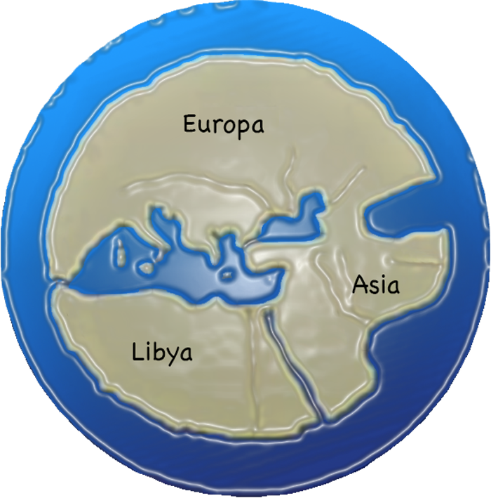
Knowledge of Europe stops at Scandinavia, knowledge of Africa stops at sub-Saharan Africa and is called Libya and knowledge of Asia stops at the pocket to the right / east of the world island, which is the Caspian Sea, which delimits Asia to what we understand by the Middle East / Asia Minor. What lay outside was unknown or at best diffuse. If you take the then known Africa called Libya and combine it with the known Asia, you get a circumference that actually corresponds to Atlantis = Antarctica. The water that encircled the world island in the Greek understanding, they called the Atlantic Ocean.
The flat-earthers have revived the Greek-medieval worldview, where the world island / land mass is a pancake floating in the middle of an encircling world ocean, behind which there is … nothing! In the medieval neo-Platonic worldview, a Christmas ball has been placed around it, sprinkled with Christmas snow, hung poinsettias on top and said: this is the Universe. It makes perfect sense that we in a time where our worldview is formed via the belief of flat screens, then the Earth must again be flat. And hey you on your way out. When you get there and look out over the edge of the pancake, please call us on the phone and tell what it looks like. The world is waiting with excitement.

The Greeks, in fact, had a strong point. The Atlantic Ocean for them was far larger than what we recognize today. And the fact that Plato tells us that there is an island = a continent on Earth that is larger than what we know today as North America (without Canada) is in itself remarkable. Plato also says that the island continent is located high. That’s completely correct, because geographically, Antarctica is the highest continent, and the rock formations that lie beneath the ice sheet are immense.

The Egyptian priest (= scientist) who informed Solon, Plato’s uncle, from whom he has handed down his account, sees the World standing from Atlantis in the distant past. The water in the World Ocean was significantly lower, we are talking about 12,000 years ago, when Atlantis was not encapsulated in bound water = ice, BUT where all the ice that was bound to most of the northern hemisphere was released and flooded the Earth.
This means as a side note that the Atlantic culture, ie the settlements on the whole globe that were immersed in either water or mud sediments on land and at sea, were exposed at that time. It also means that there was a whole strip of land bridges between the land areas that are today separated by water. England was connected to mainland Europe. The Bering Strait was a wide land bridge called Beringia, which was a land bridge between Denmark and England across the Doggerland. Japan was landlocked with Korea and Manchuria, New Guinea. Australia and Tasmania were connected land masses. South India and Sri Lanka hung together. There was a land between India and Africa called Lemuria, where the strange long-limbed primate named the Lemur lived. The Mediterranean was far smaller, etc-etc.
Plato further writes that from this island, which as mentioned was larger than Libya and Asia, the seafarers could take their way to other islands and the opposite continent that lay around the ocean.
Later in history, we encounter the same knowledge handed down through time. In the Renaissance we find a figure like Athanasius Kircher, one of the most fascinating and ultra-learned Jesuit scholars. And yes, we know what the Jesuits are, and what their agenda was and has been and still is, but their learning and acquired knowledge we should not take away from them – we should take the agenda and the use / abuse of their knowledge away from them. So Kircher was in possession of a card that may have been stolen by the Romans after Cleopatra’s fall as Egyptian queen. Similar maps ended up in Constantinople and formed the basis for later copies.
The Egyptians saw the world from above and down below. The Nile flowed downwards = to the north. Kircher accepted on his map that south is north and north is south. Using his head-turned map drawn from an Egyptian map, Atlantis is between Spain and Africa on one side and America on the other:

But what if he made a mistake on the map he copied from, and this island should be placed in relation to a completely different continent? A similar configuration emerges in the islands that make up Antarctica, for it is not just one continent below the ice core. And what if Atlantis did not only sink into the sea, but was covered by the ‘sea’ = the ice? Is that what has confused historians, so they have dismissed it as a myth?
In turn, the overall global Atlantean civilization sank into the sea, for all the coasts moved outward, covering all the settlements ideally located at the mouths of the great rivers by the coast – which now moved. Whereby the cities sank to between 50-300 meters below sea level, eg. Dwarka at Cambrai Bay west of India (60-80 m), a building complex at the size of Manhattan, and the Bimini Wall, which is much more than a masonry wall but an entire city with, among other things, pyramids (debth: 300 m). Plus a whole host of underwater locations all over the world. But these cities sank more than under the sea, they sank under the seabed, for they are covered by mud segments – just like places on land after the supposed mud rain of the 19th century.
When Plato’s uncle Solon, on his journey, spoke to one of the most learned Egyptian priests who told him about Atlantis, he began to boast of the ancient knowledge of the Greeks, after which the priest shook his head and said:
Oh, Solon, Solon, you Greeks are always children. There is no Greek that is ancient and comes from ancient traditions, nor Greek science that is round of age.
After which the priest explains that the story of the tidal wave related to Phaeton is partially complete. According to Greek mythology, the sun, Helios, was pulled by a horse-drawn carriage around the sky. Helios allows his son Phaeton to drive the chariot, but when the Sun is not strong enough, it falls out of its orbit and sets fire to the World, and Zeus has to intervene to put out the fire, creating the tidal wave.

The priest then says:
Multiple are the destructions among men, which have been, and which is to come, and the greatest is made of fire and water, but beside them is less destruction in innumerable ways. Your own story of Phaeton, the Son of the Sun, who drove his father’s orbit but himself was struck by thunderbolts, is a mythical version of reality, consisting of deviations in the bodies that populate Heaven and Earth, causing widespread fire in Heaven and on earth.

The Ut Nation among North American Indians from Colorado driven to Utah – hence the name of the state – has a similar myth about the Sun, the Son of the Sun, the fire arrows and the tidal wave. Their language is related to the Aztecs who have the myth of origin from Azlan – and no it is not borrowed from C.S. Lewis, it’s the other way around:
Antarctic ice cores look like this:

Until recently, it was claimed that the ice core of Antarctica was 50-60 million years old. Then, in 1990, a couple of researchers emerged who opened the discussion about age by discovering in a fieldwork a forest that is 2-3 million years old (by the little tree in the picture). Note, moreover, that Antarctica consists of two parts, Greater Antarctica on the right, and Lesser Antarctica on the left. South America is an extension of Lesser A, and these have been landlocked before the rise of the water.
A strange reverse geological phenomenon is that in Lesser Antarctica there is the least ice, but here all the snow falls, whereas in Greater Antarctica it is coldest, but it is a giant ice desert. That is, the snowfall we have today has not produced the layer of ice we see today. Science has no explanation for why it does not snow on the world’s largest ice cores. On the other hand, there is a similarly strange phenomenon in the northern hemisphere when studying the ice core before the end of the last ice age – at the same time as the fall of Atlantis:

It is claimed that the original inhabitants of Americans – the First Nation as they proudly call themselves, the firstborn, with Old Testament connotations – were the Prairie Indians, and that the rest of the continent including South America consisted of descendants of these peoples who migrated across the ice bridge of the time at Bering Strait and through the ice-free pocket we see on the map between the two ice fields. The first ethnological-cultural problem is how the South American high cultures with their giant buildings and advanced agricultural culture evolved from a nomadic-hunter-gatherer-stone-age culture of Siberia. The second problem is that the South American cultures can be dated to long before the arrival of the nomads in the Bering Strait. Apparently no explanation problem for historians and ethnologists. That is, except that they do not explain the problem.
The third problem is geological, because why is there an ice-free pocket between a smaller ice field to the west and a larger one to the east? The northern hemisphere was flooded until 12,000 years ago, that much we are sure about. But what did it look like in the south and especially in Antarctica? As I said, trees that were just a few million years old were found there, but what then? We have the famous Piri Reis map, which this navigator presented in 1517 to the Sultan of Constantinobel. Not only is Antarctica ice-free on his map, and the contours of the coast match what we know today under the ice. This alone is astonishing. But humans and animals also jump around in the landscape!

At the bottom of the map it says, among other things:
From eight jaferyas of the kind and an Arabic map of Hind (India) and from four recently drawn Portuguese sources showing the land of Sind (Pakistan), Hind and Qin (China) drawn geometrically and also from a map drawn by Qulunbu (Columbus) of the western region I have extracted it. By reducing all these maps to one scale, the final form emerged, so that this map of these countries is considered by sailors to be as accurate and reliable as the reliability and accuracy of the seven seas in the above maps.
Interestingly, by the way, Columbus had a finished map of the entire two American coastlines, which he could not possibly have managed to draw based on his two travels. It confirms certain assumptions that he knew full well that he was not heading to India.

Is there a possible explanation for why a now arctic area was once temperate and why the ice suddenly decided to disappear from a now temperate area, and why previous temperate or even subtropical areas turned into ice deserts? One such explanation can be found in Dr. Charles Hapgood. He argues that the Earth’s surface has at some point moved approx. a quarter turn. It has simply rotated around its own core.
Rand Flem Ath notes that the logic and sociology of science are very different. Hapgood was completely ignored by his colleagues, even though the logic of his portrayal was exemplary and should have been taken seriously. Science, for example, has no problem publishing and acknowledging research that says something similar has taken place on the planet Mars.

The earth is layered, at least according to general understanding. Here the inner core itself is liquid iron, which there may be strong reasons to doubt, but the outer layer is called the lithosphere (lithos is stone, which says it is relatively solid), resting on the next outermost layer called the asthenosphere (there is more fluid), which there is no reason to doubt. As the lithosphere moves, the rest remains stable.
The consequences of such a jerk of the outer layer would have been catastrophic and accompanied by huge earthquakes, volcanic eruptions and tidal waves not to mention the extinction of animal and plant life on a large scale.

The picture shows the former polar zone, where there was ice together with the then temperate. This means that Alaska, Siberia and northern Norway were in a warm zone, which is confirmed by the discovery of animals in the area that otherwise belong in eg Africa, eg hyenas. After the landslide of the lithosphere, these areas became Arctic. Greenland was both then and today iced, because it is in the common denominator of the two circles.
There is a ring around the Earth where the wildlife was exterminated in particular. It is precisely this circle that experienced the greatest difference in climate because the land moved, whereas the land with the transverse coordinates simply rotated. The hyena that ran around in a subtropical Siberia did not survive being transplanted to an Arctic Alaska. The lions of Africa rotated around their own axis, but the mammoths of North America died.

America was at once to be considered part of Asia. So Asians have been able to move effortlessly from Siberia to Alaska before the turnaround, where both lands were ice-free. When the turnaround arrived, these people were living in present-day United States. In the Native American tales, Mount Shasta is sacred mountain in the same way that Ararat is to the Armenians. The similarity is, that it was high mountains where the people sought refuge when the waters rose.

What is even more interesting is, that the same tales include travelers who arrived with boats from a homeland that had been destroyed. We all know the story of Noah, who describes it from the point of view of one man and his family – we remember again that we must read it as an allegory. But few people know the similar stories from America. The Okanaga Indians report, that their ancestors escaped a sinking island in the middle of an ocean.
Off the coast of British Columbia in Western Canada lies an archipelago called the Queen Charlotte Islands with an indigenous population called Haida, who tell that:
Their ancestors long ago lived in the world’s largest village. Life was carefree, until the Leader of Heaven decided to destroy humanity by changing Heaven and creating a flood of the World. The survivors escaped to a new land, where they landed on a mountain top, and a new era began.
The stories of the mountains as landing sites is to be found all over the World. Fujiyama, Ararat, Kilimanjaro, Mount Baker (Okanaga history), Lake Titicaca (the highest lake in the world).
In Japan in the year 691 (it might be a bit off, since he was only emperor till 686), Emperor Temnu ordered his imperial narrators to write down the oldest myths. It became the book Kojiki, where it is said that a country in times where the world was very young was called Onogoro Jima was close to the North or South Pole (question of interpretation). This may be a synonym for Antarctica.

Flem Ath’s presentation does not take into account that there may have been two continents, one of which could be the ocean sunken – cf. the Mercator projection, which shows a four-part land mass in the Arctic Ocean (current, then temperate climate) .
The resurgence of agriculture
After the Flood, life returned. It is remarkable, however, that the agrarian cultures originated simultaneously on different continents 12,000 years ago. Until then, there were collectors and hunters and kaboom! suddenly there were farmers! What we would call primitive cultures just overnight became more advanced. Historians / archaeologists are not very good at explaining it, which is not so strange, as they completely rule out the existence of two very different cultures on Earth that were not mixed at the same time – yet, one advanced and one primitive.
All agriculture is seen for the first time in history in a large crescent-shaped zone between the old tropics of cancer and the new one after the earth turn.

The country with the largest land area within the fertile crescent is China, and China has the largest number of different crops. India has the second highest number of different crops.
In Indian, one of the early leaders of the national uprising against the British was thrown in jail. His name was Bal Gangadar Tilak and was one of Gandhi’s role models.

He spent a number of years in his prison studying the Vedas, for that was all they let him read. When he was finally released after 6-7 years in prison in 1903, he took to the mountains, after which he came out with a book called The Arctic Home of the Vedas.
Ahura Mazda warns Yima, the first king of mankind, of the arrival of a harsh winter that will destroy all living beings by covering the land with a thick blanket of ice, and he advises Yima to build a warehouse, an enclosure to protect all animals and humans (the ark). The Zend-Avesta text can be read here:
www.sacred-texts.com/zor/toz/toz05.htm
– but in short, Ahura Mazda advises the human king to survive the winter = ice age = the movement of the Arctic to tropical and vice versa and subsequently to cultivate the land, after escaping with his deputy (ark) from his home near the Pole – North or South? probably the North because of the distance + Mercator’s map + Russian historian Nicolai Levashov’s reading of the Slavic Vedas, which is an extension of the scriptures that Tilak read. But we can’t be sure.
Ahura Mazda is the deity of the good forces in Persian mythology, and Ahriman is the representative of the evil forces. So which of these two deities (according to the Haida people of Canada) made the decision to remake the sky and create flooding? It is not that hard to figure out.
In Sumerian civilization, they have the story of Dilmun, which corresponds to the Zend-Avestas and the Haida people. Linguists have strangely enough found similarities in Sumerian and Haida and their narrative is almost literally identical, which is quite a span in distance. But language and narrative do not lie, no matter what historians may claim.
Egypt is from where we in the West have the Atlantis story. Where were the Egyptians during the flood? And we are not talking about dynastic Egypt but about the original creators of Khemt, the land by the river with the black soil. The builders of the Sphinx and the pyramids. They were in the Ethiopian highlands, the landing site of the survivors of Atlantis at the high-lying freshwater lake Tana. It is halfway between the old and the new equator of the tropic of cancer, the fertile crescent where all agriculture originated. NB, the Ethiopian connection to the Ark of the Covenant, a handed down artifact from a hi-tech civilization. Survivors spread after the disaster down the Blue Nile to Sudan, to the confluence of the Blue Nile and the White Nile at Khartoum, where agricultural culture originated 12,000 years ago.
A pattern of landing sites for the sailing survivors from Atlantis is beginning to emerge. In the same circular periphery we find Spirit Cave in Thailand and Lake Titicaca in Peru.

The common denominator for all the landing sites was a stable ecology. Elsewhere, there was total destruction, extinct animal breeds and waste land.
The inhabitants of Lake Titicaca are called the Ameras, and their language is very special. It is strictly structured and simple. Its syntax is always stable. It can be printed in algebraic abbreviation, which even computers can understand. Some historians have suggested that it not only originated through evolution over time but was created and designed from scratch. An artificial language then. The logic is not binary, but trinary, which may well become the next computer language.
The Ameras also have a different view of time. They see the future as lying behind, a hidden place that they cannot yet see. Someday they will get there, but they do not have to focus on it.
The City Atlantis
According to Plato, the city of Atlantis was enormous, like modern-day London. He also comes up with a hint about where in Antarctica, the city is located: Midway from the sea side surrounded by mountains.
Thus enriched – or perhaps confused – by not just one but two sunken kingdoms in human history, we round off the story. First we have one kingdom, then we have another, and then we have none of them. But there is a direct connection between them, even though the span in time is large and there are many dead points and missing links.

One connection that is quite disturbing is that it seems to be the same warring groups that existed then in the morning of the times and today. We are today on the other side of it what is described as a complete yuga cycle of 24,000 years. 12,000 years ago, something took place that is only being clarified today. The disturbing turns out to be the uplifting.
Both Edgar Cayce and Rudolf Steiner tell us about the two groups from Atlantis, Belael (Baal) and Emilius, where the first used their knowledge, power and technology for their own purposes destructive to others, and the second group saw themselves as protectors of humans.
Tartaria was the landing site for the survivors. Their culture was unbroken until the parasites took over. Today in the 11th hour the wind turns again and blows the other way.


